

Satellites Show Logging Decline in Peruvian Amazon
By Stephen Leahy
Deforestation in the Peruvian Amazon, intense in zones near roads and mining operations, has had little impact in protected forests, say researchers.
Aug 13 (Tierramérica).- Rainforest conservation policies are reducing the rate of deforestation in the Peruvian Amazon, but roads are unquestionably the drivers of change, new satellite data reveal.
Although Brazil’s Amazon forests draw the most international attention, Peru’s 661,000 square kilometers of rainforests are recognized as a unique and important ecosystem.
However, the impacts of human activities throughout the region have been poorly understood, until a study published Aug. 10 in the journal Science.
“Peru’s forest reserves and conservation areas appear to be working well,” said Greg Asner, director of the Carnegie Airborne Observatory, at Stanford University in California.
Deforestation and other disturbances of forested areas — selective logging, oil exploration and mining — increased about 127,700 hectares per year on average from 1999 to 2005, with just two percent occurring in protected areas, according to the study by Asner and colleagues.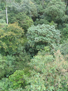
By contrast, Brazil’s four million-square-kilometer Amazon forest region loses 2.0 million to 2.4 million hectares annually, with about 10 percent occurring in protected areas.
Better land use policies and the remoteness of the forest in Peru are likely reasons why there has been much less forest loss there, Asner told Tierramérica. Peru has also long had a national forest policy that granted logging concessions, whereas Brazil has only recently implemented a similar system, he said.
Using a satellite-based forest disturbance detection system originally designed and used to measure forest loss in Brazil, along with on-the-ground fieldwork, the study found that 86 percent of all forest damage was concentrated in only two regions: the area around the Ucayali logging center of Pucallpa, and along the associated road network.
The satellite data reveals a great deal of logging “leakage” outside the concession areas into nearby forests, he said. Although it is difficult to know precisely what is occurring, Asner suspects that once an area has been opened up to logging, concession-holders or others simply move into nearby areas.
The study clearly shows that deforestation follows the construction of the Inter-Oceanic Highway, which ultimately is directly connected with 23 percent of the total damage. “Roads are absolutely connected to deforestation,” he said.
Loggers are chasing “red gold”, the valuable wood of mahogany trees, which are still found in commercial quantities in the Peruvian Amazon, says David Hill, a campaigner for Survival International, a Britain-based non-governmental organization supporting tribal peoples worldwide.
“‘Tree laundering’ is going on, with mahogany supposedly coming from legal concessions being brought in from outside,” Hill told Tierramérica. It is very difficult to monitor or trace the origin of logs in such remote regions, he said.
“Legal logging concessions are facilitating illegal extraction,” he explained.
For complete story see Satellites Show Logging Decline in Peruvian Amazon Also available in Spanish — Satélites revelan caída de tala amazónica en Perú and Portuguêse — Satélites revelam redução no desmatamento amazônico no Peru
