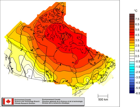
 Canada’s average temperature for 2010 was 3.0°C above normal — the warmest year on record (source: Environment Canada)
Although cooler in the south where every one lives, Canada’s north has been breaking records for warmth in the middle of winter in a region where there is no sun until spring! I’ve covered this a couple of weeks ago and the reasons why Arctic Hothouse Turns Europe into an Icebox
This is a more recent report from the National Center for Atmospheric Research in Boulder by Bob Henson. — Stephen
 “Just how mild has it been? The map at right shows departures from average surface temperatures for the period from 17 December 2010 to 15 January 2011, as calculated by NOAA’s Earth Systems Research Laboratory.
The blue blip along the southeast U.S. coast indicates readings between 3°C and 6°C (5.4–10.8°F) below average for the 30-day period as a whole…
What really jumps out, though, is a blob of green, yellow, orange, and red covering a major swath of northern and eastern Canada. The largest anomalies here exceed 21°C (37.8°F) above average, which are very large values to be sustained for an entire month.
To put this picture into even sharper focus, let’s take a look at Coral Harbour, located at the northwest corner of Hudson Bay in the province of Nunavut. On a typical mid-January day, the town drops to a low of –34°C (–29.2°F) and reaches a high of just -26°C (–14.8°F). Compare that to what Coral Harbour actually experienced:
- On the 6th of the month, the low temperature was –3.7°C (25.3°F). That’s a remarkable 30°C (54°F) above average.
- On both the 5th and 6th, Coral Harbor inched above the freezing mark. Before this year, temperatures above 0°C (32°F) had never been recorded in the entire three months of January, February, and March.
Related articles/posts:


