Hurricane Sandy a Taste of More Extreme Weather to Come

By Stephen Leahy

UXBRIDGE, Canada, Nov 2 2012 (IPS)

Killing nearly 200 people in the United States, Canada and the Caribbean and crippling much of New York City and surrounding areas earlier this week, Hurricane Sandy was the kind of extreme weather event scientists have long predicted will occur with global warming.

“Climate change is a reality,” said New York Governor Andrew Cuomo after Sandy swept through his state.

Sandy was twice the size of an average hurricane, and it hit the eastern coast of the United States, where sea levels have been rising the fastest, said Kevin Trenberth, senior scientist at the National Center for Atmospheric Researchin Boulder, Colorado.

“All weather events are affected by climate change because the environment in which they occur is warmer and moister than it used to be,” Trenberth, an expert on extreme events, told IPS.

Whether climate change caused Hurricane Sandy is the wrong question to ask, added Trenberth. He explained that climate change helped make Hurricane Sandy more destructive than it otherwise would have been.

“This is the new normal,” Trenberth said. “It doesn’t make sense to rebuild in some regions – they’ll just be swept away again.”

Persistent La Niña Is Back Again — And Driving Up Food Prices

By Stephen Leahy *

UXBRIDGE, Canada, Oct 11, 2011 (Tierramérica)

La Niña is back less than three months after the end of its last appearance, a particularly strong event that contributed to driving up global food prices.

The new La Niña will continue the largely dry conditions in important agricultural regions in Brazil and Argentina as well as the southern United States and hurt yields of soy and wheat, experts say.

“Multi-year La Niñas are not uncommon,” said Jeff Masters, co-founder and director of meteorology for Weather Underground, the web’s first commercial weather service.

“The last was between 1998 to 2001 with a few months of neutral conditions like this year,” Masters told Tierramérica.

La Niña and El Niño are, respectively, the cold and warm phases of the famous El Niño-Southern Oscillation (ENSO), a cyclical climate phenomenon that affects weather patterns around the world.

ENSO is part of the system that regulates heat in the eastern tropical Pacific Ocean and is driven by changes in surface ocean temperature and air pressure.

“ENSO is undoubtedly being affected by climate change,” said Masters.  Continue reading

Northern Canada’s Winter Heat Wave

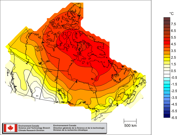
Canada’s average temperature for 2010 was 3.0°C above normal — the warmest year on record (source: Environment Canada)

Although cooler in the south where every one lives, Canada’s north has been breaking records for warmth in the middle of winter in a region where there is no sun until spring! I’ve covered this a couple of weeks ago and the reasons why Arctic Hothouse Turns Europe into an Icebox

This is a more recent report from the National Center for Atmospheric Research in Boulder by Bob Henson. — Stephen

“Just how mild has it been? The map at right shows departures from average surface temperatures for the period from 17 December 2010 to 15 January 2011, as calculated by NOAA’s Earth Systems Research Laboratory.

The blue blip along the southeast U.S. coast indicates readings between 3°C and 6°C (5.4–10.8°F) below average for the 30-day period as a whole…

What really jumps out, though, is a blob of green, yellow, orange, and red covering a major swath of northern and eastern Canada. The largest anomalies here exceed 21°C (37.8°F) above average, which are very large values to be sustained for an entire month.

To put this picture into even sharper focus, let’s take a look at Coral Harbour, located at the northwest corner of Hudson Bay in the province of Nunavut. On a typical mid-January day, the town drops to a low of –34°C (–29.2°F) and reaches a high of just -26°C (–14.8°F). Compare that to what Coral Harbour actually experienced:

  • On the 6th of the month, the low temperature was –3.7°C (25.3°F). That’s a remarkable 30°C (54°F) above average.
  • On both the 5th and 6th, Coral Harbor inched above the freezing mark. Before this year, temperatures above 0°C (32°F) had never been recorded in the entire three months of January, February, and March.

Related articles/posts:

Climate Change Could Be Worsening Effects of El Niño -La Niña

Ice-cold Atlanta (and eastern US) Is Likely Connected to Arctic Hothouse

The Yin and Yang of Climate Extremes We Will See More of