Radio EcoShock: Ravaging Tide or Renewable World?

Flooding of New Jersey shoreline

Can big cities like New York or Washington protect against storm surge and rising seas?


I highly recommend this excellent weekly radio show: RADIO ECOSHOCK  hosted by Alex Smith  — Stephen

Nov 7 Show:  

Mike Tidwell, author of “The Ravaging Tide: Strange Weather, Future Katrinas, and the Coming Death of America’s Coastal Cities.”

Professor J. Court Stevenson, University of Maryland, on city surge defenses around the world.

Daphne Wysham interviews German Green Parliamentarian Hermann Ott: leading the way to renewables before climate collapse.

Website: Radio Ecoshock 121107 1 hour

FREE DOWNLOAD: Download/listen to show in CD Quality (56 MB)

Hurricane Sandy a Taste of More Extreme Weather to Come

By Stephen Leahy

UXBRIDGE, Canada, Nov 2 2012 (IPS)

Killing nearly 200 people in the United States, Canada and the Caribbean and crippling much of New York City and surrounding areas earlier this week, Hurricane Sandy was the kind of extreme weather event scientists have long predicted will occur with global warming.

“Climate change is a reality,” said New York Governor Andrew Cuomo after Sandy swept through his state.

Sandy was twice the size of an average hurricane, and it hit the eastern coast of the United States, where sea levels have been rising the fastest, said Kevin Trenberth, senior scientist at the National Center for Atmospheric Researchin Boulder, Colorado.

“All weather events are affected by climate change because the environment in which they occur is warmer and moister than it used to be,” Trenberth, an expert on extreme events, told IPS.

Whether climate change caused Hurricane Sandy is the wrong question to ask, added Trenberth. He explained that climate change helped make Hurricane Sandy more destructive than it otherwise would have been.

“This is the new normal,” Trenberth said. “It doesn’t make sense to rebuild in some regions – they’ll just be swept away again.”

Sandy Says: “Bigger Superstorms Coming Unless Dial Down Thermostat”

Alaska temps in degrees F

I was born just over a week ago and more than 100 people have died in the US and Caribbean region as a result. For the rest of today please take care as I will continue to bring strong winds, heavy rains and snowfall from North Carolina to well into Canada. Some of the worst flooding hit Haiti in the hours after I’d passed by.

Read full post at Hurricane Sandy Speaks (crosspost)

Sandy Says: Not “Targeting” New York or Anywhere Else

To be absolutely clear: I am not “targeting” New York City or anywhere else. I am pushed and pulled by temperature and pressure differences. My winds are powered by warm water and moisture. And there is enough heat and moisture for my winds to make 12-foot high waves over a 3 million sq km area – one third the size of the US.

Read full post at Hurricane Sandy Speaks (crosspost)

Hurricane Sandy Speaks: “People call me Frankenstorm, SuperStorm, WeatherBomb…”

Hi, this is Sandy. People are calling me ‘Frankenstorm’, ‘Superstorm’ and even ‘Weatherbomb’.

I don’t mean to hurt anyone but the record moisture in the atmosphere and heat in the ocean has given me uncontrollable power. I probably will cause billions of dollars of damage in Washington, New York City Boston and other parts of the Northeast. And I will kill some people, I already have. At least 66 people died when I swept through Jamaica and Cuba a few days ago.

I am a force of nature but you have to understand this is not all my fault.

Read full post at Hurricane Sandy Speaks (crosspost)

Extreme weather new normal with Climate Change

Climate change plays a role in all extreme weather now – atmosphere is 0.8C hotter and 4-6% wetter – turns out small increases can have big impacts. — Stephen

Stephen Leahy, International Environmental Journalist

By Stephen Leahy

CAIRNS, Australia, Apr 3, 2012 (Tierramérica)

Extreme weather is fast becoming the new normal. Canada and much of the United States experienced summer temperatures during winter this year, confirming the findings of a new report on extreme weather.

For two weeks this March most of North America baked under extraordinarily warm temperatures that melted all the snow and ice and broke 150-year-old temperature records by large margins.

Last year the U.S. endured 14 separate billion-dollar-plus weather disasters including flooding, hurricanes and tornados.

A new report from the Intergovernmental Panel on Climate Change (IPCC), released Mar. 28, provides solid evidence that record-breaking weather events are increasing in number and becoming more extreme. And if current rates of greenhouse gas emissions are maintained, these events will reach dangerous new levels over the coming century.

Since 1950 there have been many more heat waves and record warm temperatures than in…

View original post 768 more words

Extreme Weather is the New Normal with Climate Change

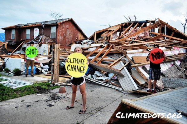
Aftermath of an early tornado in Lancaster, Texas. To join thousands of others connecting the dots between climate change and extreme weather, visit ClimateDots.org.

By Stephen Leahy

CAIRNS, Australia, Apr 3, 2012 (Tierramérica)

Extreme weather is fast becoming the new normal. Canada and much of the United States experienced summer temperatures during winter this year, confirming the findings of a new report on extreme weather.

For two weeks this March most of North America baked under extraordinarily warm temperatures that melted all the snow and ice and broke 150-year-old temperature records by large margins.

Last year the U.S. endured 14 separate billion-dollar-plus weather disasters including flooding, hurricanes and tornados.

A new report from the Intergovernmental Panel on Climate Change (IPCC), released Mar. 28, provides solid evidence that record-breaking weather events are increasing in number and becoming more extreme. And if current rates of greenhouse gas emissions are maintained, these events will reach dangerous new levels over the coming century.

Since 1950 there have been many more heat waves and record warm temperatures than in previous decades.

This will only increase in future decades, as will heavier rainfall events in tropical regions and the high latitudes, according to the Special Report on Managing the Risks of Extreme Events and Disasters to Advance Climate Change Adaptation (SREX). 

The hottest day that occurs once in 20 years is likely to become a one-in-two year event by the end of the century, except in the high latitudes of the Northern hemisphere, where it is likely to happen once every five years.

The average tropical cyclone maximum wind speed is likely to increase, but the global frequency of tropical cyclones is likely to decrease or remain unchanged.

Continue reading

Cyclone Bingiza Hits Madagascar, Now Mozambique with Serious Flooding Pix

Bingiza off north east coast of Madagascar

Landfall Feb 14 Valentine’s Day

[Update 17 Feb:  Cyclone Bingiza to Worsen Mozambique, Madagascar Floods, UN Says see here for South African flooding NASA sat pix]

This is a big Cat 3 cyclone expected to affect 100,000’s of people. Sustained wind speeds of 160 kilometres per hour with gusts of up to 220 kilometres per hour, have been reported

NASA’s Terra satellite captured this image of Bingiza at 10:00 a.m. local time on Feb. 13, 2011. In the image, Bingiza’s eye approaches northern Madagascar, and a spiral arm grazes Antananarivo.

Related

Will Super Cyclone Yasi be Australia’s Katrina? Landfall Wed as Cat 5 Storm

The Yin and Yang of Climate Extremes We Will See More of

Hurricane Madness – 3 Hurricanes Spinning At One Time PIX


Stunning Satellite Pix of SuperCyclone Yasi on Landfall (and video)

Taken by MTSAT on February 2nd, 2pm (click for larger view)

The newly operational MTSAT-2 images from February 2nd are particularly striking. The images, showing the coldest clouds as white, reveal the extent of swirling white cloud and the deep eye of the storm which is clearly visible just off the coast of Northern Australia. — University of Leicester

My full posting of Yasi including graphs and pixs Will Super Cyclone Yasi be Australia’s Katrina?

Click to see amazing video of the approach of the cyclone on YouTube

“We’re Running the Risk of Unstoppable Climate Change” — Oceanographer

Interview with leading marine scientist Chris Reid

“I’m afraid it is going to take a major catastrophe in the developed world…”

GIJON, Spain, Jun 4 (IPS) – Warming seawater, melting sea ice and glaciers, sea level rise, storm intensification, changes in ocean currents, growing “dead zones”, and ocean acidification are just some of the signs that the oceans that cover 71 percent of our watery planet are changing.

Changes in the oceans also means major impacts on the land and the atmosphere. “Policy makers and the public do not realize that the oceans are the drivers of the climate system,” says Chris Reid, recently retired professor of oceanography at the Sir Alister Hardy Foundation for Ocean Science in Plymouth, England.

Reid will be producing a report this summer on the impacts the altered oceans are having and will have on the global climate.

IPS environment correspondent Stephen Leahy spoke to Reid at an international scientific symposium held late last month in Gijon, Spain on the effects of climate change on the world’s oceans.

IPS: What is happening in the oceans that will affect the global climate?

CR: The oceans have absorbed 30 percent of all human emissions of carbon dioxide (CO2) since the start of the industrial age. There is now good evidence that the oceans are absorbing less carbon as a result of climate change. The warming of surface waters, glacial and sea ice meltwater, acidification and so on are inhibiting or slowing a number of the oceans’ mechanisms for absorbing carbon from the atmosphere and safely storing them in the deep ocean.

IPS: How will that affect us?

CR: It means the atmospheric concentrations of CO2 will rise much faster than has been previously projected by climate scientists. Human carbon emissions are already on pace for the worst case scenario as envisioned by the IPCC (Intergovernmental Panel on Climate Change). These changes in the oceans means the rate of warming will increase, bringing even more severe hurricanes and cyclones, flooding events and so on.

IPS: Cyclones like the one that recently devastated Burma?

CR: Yes. Research presented at this meeting shows that South Korea and Japan are experiencing more powerful cyclones. While a single event can’t be precisely connected to climate change, the Burma cyclone fits what is expected with climate change. Continue reading