Record Arctic Ice Melt Threatens Global Security

Rapidly warming planet biggest threat to all nations

Military budget more than enough to convert USA to 100% renewable energy

Analysis by Stephen Leahy

UXBRIDGE, Canada, Sep 15, 2011 (IPS)

All the analysis and commentary about safety and security on the tenth anniversary of 9/11 ignored by far the biggest ongoing threat to global security: climate change.

Just days before Sunday’s commemoration of the attacks, German scientists pointed to yet another smoking gun of climate change: the Arctic sea ice reached a new historic minimum ice extent.

The rapidity with which the planet is losing its northern ice cap continues to astonish experts. The defrosting northern pole is one of the prime drivers of Earth’s climate system and is changing global weather patterns in unpredictable ways.

The Arctic ice melt is also accelerating the rate of climate change beyond what humanity is doing with every barrel of oil, tonne of coal or cubic metre of gas burned.

On Sep. 8, researchers at the University of Bremen in Germany reported that the Arctic ice melt bettered the previous minimum of 2007. Other research centres using different satellite and analysis tools say the extraordinary decline of ice in 2007 has not yet been exceeded this year and 2011 remains a close second.

Sea Ice Extent 2003-2011

“We think it will end up a little bit short of the record – not that it really matters,” said Mark Serreze, director of the National Snow and Ice Data Center in the U.S. city of Boulder, Colorado.

“What is extraordinary this year is that there was no weird weather pattern that created the perfect conditions for the record melt in 2007,” Serreze told IPS.

This independent environmental journalism depends on public support. Click here learn more.

This year, the summer weather was normal and yet it the ice vanished in similar amounts to 2007.

“That tells us the sea ice is too thin now to hold up under normal weather conditions,” he said.

Continue reading

Permafrost Melt Soon Irreversible Without Major Fossil Fuel Cuts

Thawing Permafrost Will Accelerate Climate Disruption

By Stephen Leahy

UXBRIDGE, Canada, Feb 17, 2011 (IPS)

Thawing permafrost is threatening to overwhelm attempts to keep the planet from getting too hot for human survival.

Without major reductions in the use of fossil fuels, as much as two-thirds of the world’s gigantic storehouse of frozen carbon could be released, a new study reported. That would push global temperatures several degrees higher, making large parts of the planet uninhabitable.

Once the Arctic gets warm enough, the carbon and methane emissions from thawing permafrost will kick-start a feedback that will amplify the current warming rate, says Kevin Schaefer, a scientist at the National Snow and Ice Data Center (NSIDC) in Boulder, Colorado. That will likely be irreversible.

This independent environmental journalism depends on public support. Click here learn more.

And we’re less than 20 years from this tipping point. Schaefer prefers to use the term “starting point” for when the 13 million square kilometres of permafrost in Alaska, Canada, Siberia and parts of Europe becomes a major new source of carbon emissions.

“Our model projects a starting point 15 to 20 years from now,” Schaefer told IPS. Continue reading

‘Snow Bomb’ Collapses 100s of Homes in S. Korea – Satellite Pix

More than 1 metre (three feet) last weekend – 50 cm more coming

The heaviest snowfall in more than a century on South Korea’s east coast is causing widespread chaos. Hundreds of houses have collapsed under the weight of the snow. One newspaper described it as a snow bomb. The South Korean government has deployed 12,000 soldiers to rescue stranded residents.

Warmer than normal ocean temperatures are being blamed. This is similar to the warmer Arctic ocean temps in late Dec that contributed to the big snows and cold in North America, UK and parts of Europe.

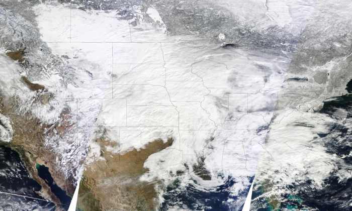
[Update: Great sat pix from NASA showing the entire eastern half of Korea covered in snow. See also pix of Southern USA blanketed in more record-breaking snow last week]

NASA reports: “The heavy snowfall arrived on the heels of South Korea’s coolest January since the 1960s. The unusual cold might have been driven at least partly by the Arctic Oscillation (AO). A negative phase of the AO lowered temperatures in other parts of the Northern Hemisphere in January 2011.”

See also:

Arctic Defrost Dumping Snow on U.S. and Europe

The Great Groundhog’s Day Blizzard – Worst Winter Storm in 60 Years

Arctic Sea Ice Record – New Satellite Image

Arctic Sea Ice Record – New Satellite Image

Temperatures of +21C above normal in Dec/Jan in the eastern Arctic. Parts of Hudson Bay remain unfrozen

This NASA image shows average Arctic sea ice concentration for January 2011. Blue indicates open water; white indicates high sea ice concentrations; and turquoise indicates loosely packed sea ice. The yellow line shows the average sea ice extent for January from 1979 through 2000.

The U.S. National Snow and Ice Data Center (NSIDC) has reported that Arctic sea ice was at its lowest extent ever recorded for January (since satellite records began).

I’ve written about why this is happening and the consequences several times in recent weeks — Stephen

Arctic Defrost Dumping Snow on U.S. and Europe

Arctic Melt Down Is Bringing Harder Winters and Permanently Altering Weather Patterns

East Coast Blizzard and Europe’s Snowmaggddon Reveal Fingerprints of Climate Change

Arctic Hits Bottom – Lowest Jan Sea Ice Cover Ever*

1.27 million square kilometers below avg


The National Snow and Ice Data Center reported wednesday that the Arctic sea-ice extent averaged just 13.55 million square kilometers, the lowest January ice extent since satellite records began in 1979 (*and likely the lowest in thousands of years– SL). That’s a whopping 1.27 million square kilometers below the 1979 to 2000 average.

No surprise given the absurdly warm Arctic temperatures of +21C above normal in Dec/Jan.

I’ve written about why this is happening and the consequences several times in recent weeks:

Arctic Defrost Dumping Snow on U.S. and Europe

Arctic Melt Down Is Bringing Harder Winters and Permanently Altering Weather Patterns

East Coast Blizzard and Europe’s Snowmaggddon Reveal Fingerprints of Climate Change

The Arctic summer’s sea ice melt will likely be another record low pushing the world to an ice-free Arctic one summer in the new future. FYI weather-related records will continue to fall faster than dominos without drastic cuts to our fossil fuel emissions. And frankly I’m tired of writing about it. — Stephen

The Great Groundhog’s Day Blizzard – Worst Winter Storm in 60 Years

Images Modis sat - January 31 at 10:30 a.m., 12:05 p.m., and 1:45 p.m. Eastern Time

This is what climate change looks like

One of the largest winter storms since the 1950s has hit 30 U.S. states from New Mexico to Maine and now into central and eastern Canada — +100 million people affected, hundreds of thousands without power. Chicago could get buried by more than 60 centimeters (2-ft) of snow — hundreds stranded already.

Climate change is certainly playing a role in this massive storm.

1. Warmer global temps means there is now four per cent more water vapour in the atmosphere which means heavier snowfalls.

2. There is also more energy in the climate system which makes storms more powerful.

3. Finally the melting of the Arctic sea ice is changing wind patterns in the polar regions bring colder, wetter winters to the eastern US  and western Europe scientists told me several months ago. (See my previous post East Coast Blizzard and Europe’s Snowmaggddon Reveal Fingerprints of Climate Change

Climate change loads the dice in favour of extreme events.

My latest article on this The Yin and Yang of Climate Extremes We Will See More of. — Stephen

Recent related articles:

Climate Change Could Be Worsening Effects of El Niño, La Niña

Arctic Melt Down Is Bringing Harder Winters and Permanently Altering Weather Patterns

Arctic Ice in Death Spiral, Thaws Permafrost — Risks Climate Catastrophe

Northern Canada’s Winter Heat Wave

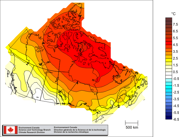
Canada’s average temperature for 2010 was 3.0°C above normal — the warmest year on record (source: Environment Canada)

Although cooler in the south where every one lives, Canada’s north has been breaking records for warmth in the middle of winter in a region where there is no sun until spring! I’ve covered this a couple of weeks ago and the reasons why Arctic Hothouse Turns Europe into an Icebox

This is a more recent report from the National Center for Atmospheric Research in Boulder by Bob Henson. — Stephen

“Just how mild has it been? The map at right shows departures from average surface temperatures for the period from 17 December 2010 to 15 January 2011, as calculated by NOAA’s Earth Systems Research Laboratory.

The blue blip along the southeast U.S. coast indicates readings between 3°C and 6°C (5.4–10.8°F) below average for the 30-day period as a whole…

What really jumps out, though, is a blob of green, yellow, orange, and red covering a major swath of northern and eastern Canada. The largest anomalies here exceed 21°C (37.8°F) above average, which are very large values to be sustained for an entire month.

To put this picture into even sharper focus, let’s take a look at Coral Harbour, located at the northwest corner of Hudson Bay in the province of Nunavut. On a typical mid-January day, the town drops to a low of –34°C (–29.2°F) and reaches a high of just -26°C (–14.8°F). Compare that to what Coral Harbour actually experienced:

  • On the 6th of the month, the low temperature was –3.7°C (25.3°F). That’s a remarkable 30°C (54°F) above average.
  • On both the 5th and 6th, Coral Harbor inched above the freezing mark. Before this year, temperatures above 0°C (32°F) had never been recorded in the entire three months of January, February, and March.

Related articles/posts:

Climate Change Could Be Worsening Effects of El Niño -La Niña

Ice-cold Atlanta (and eastern US) Is Likely Connected to Arctic Hothouse

The Yin and Yang of Climate Extremes We Will See More of

    Record-breaking temps 20C above norm in Arctic in January

    Arctic Hothouse Turns UK, Europe, Eastern North America into an Icebox

    It remains shockingly warm in much of the eastern Arctic (See my previous post that explains what is happening Arctic Hothouse Turns Europe into an Icebox )

    Iqaluit one of the most northern communities in Canada is +2.1.C  (Jan 6) — a whopping 20C above normal as it has been for weeks. Normal night temps are -30C. This winter heat wave is creating havoc with rain instead of snow throughout much of the eastern Arctic.

    Part of the reason is the heat stored in the Arctic ocean from this summer’s ice melt has delayed the annual freeze up. Here is the very latest satellite measurements which show the Arctic sea ice extent for December as the lowest on record.

    This is affecting winter weather in many places such as Britain which had its coldest Dec in 100 years. And yes, climate change is a major player in all this.

    For more on this see Joe Romm’s take on Climate Progress.

    This is part of Community Supported Environmental Journalism, independent reporting supported by citizens in several countries thru one-time, weekly or monthly or in-kind donations.

    Arctic Hothouse Turns Europe into an Icebox

    Here’s a temperature map from mid December illustrating the super warm Arctic region and the icy cold Europe in the mid-latitudes. [[ see also temp anomaly chart showing Hudson Bay to Greenland is 18C above normal this week]]

    My previous post explains what is going on: East Coast Blizzard and Europe’s Snowmaggddon Reveal Fingerprints of Climate Change

    — Stephen

    And here is the Arctic sea ice extent – lowest ever for December.

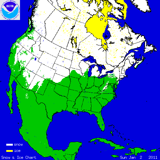
    As of Jan 2 Canada’s Hudson Bay is still not completely frozen over – likely the latest freeze up in a very long time. (10,000s of years?)


    East Coast Blizzard and Europe’s Snowmaggddon Reveal Fingerprints of Climate Change

    Coldest Christmas on Record on the UK -18C

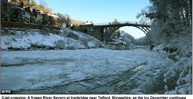
    In Oslo last June climate researcher’s told me the melting Arctic ice will likely produce colder winters in the eastern United States and Europe. Looks like they were right. Winter freeze up in the sunless Arctic ocean was two months late this year because of a near record ice loss last summer that is expected to continue if not accelerate in future years.

    Several research programs have been studying the impacts of this huge loss in Arctic sea ice and presented their findings for first time at the International Polar Year Oslo Science Conference. My summary from 15 June:

    Climate change has warmed the entire Arctic region, melting 2.5 million square kilometres of sea ice, and that, paradoxically, is producing colder and snowier winters for Europe, Asia and parts of North America.

    “The exceptional cold and snowy winter of 2009-2010 in Europe, eastern Asia and eastern North America is connected to unique physical processes in the Arctic,” said James Overland of the NOAA/Pacific Marine Environmental Laboratory in the United States.

    In future, cold and snowy winters will be the rule rather than the exception” in these regions, Overland told IPS.

    Thanks to support from readers and the organizers of the conference I was able to attend that polar science conference. No media/publication would front any travel money to help me get there. I was one of a small handful of jurnos there and the first to write a piece documenting the link between global warming and bitter winter weather.

    This independent environmental journalism depends on public support. Click here learn how this works.

    My full article from Oslo is here: Arctic Melt Down Is Bringing Harder Winters and Permanently Altering Weather Patterns