Cyclone Bingiza Hits Madagascar, Now Mozambique with Serious Flooding Pix

Bingiza off north east coast of Madagascar

Landfall Feb 14 Valentine’s Day

[Update 17 Feb:  Cyclone Bingiza to Worsen Mozambique, Madagascar Floods, UN Says see here for South African flooding NASA sat pix]

This is a big Cat 3 cyclone expected to affect 100,000’s of people. Sustained wind speeds of 160 kilometres per hour with gusts of up to 220 kilometres per hour, have been reported

NASA’s Terra satellite captured this image of Bingiza at 10:00 a.m. local time on Feb. 13, 2011. In the image, Bingiza’s eye approaches northern Madagascar, and a spiral arm grazes Antananarivo.

Related

Will Super Cyclone Yasi be Australia’s Katrina? Landfall Wed as Cat 5 Storm

The Yin and Yang of Climate Extremes We Will See More of

Hurricane Madness – 3 Hurricanes Spinning At One Time PIX


Amazon Drought Accelerating Climate Change

World’s Forests Losing Their Green. Billions of tonnes of CO2 Released

By Stephen Leahy

UXBRIDGE, Canada, Feb 3, 2011 (IPS)

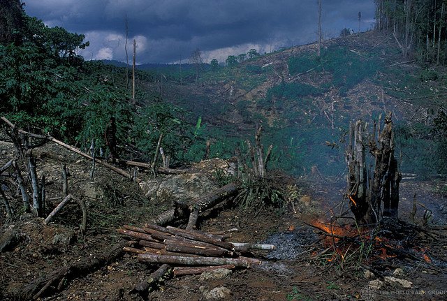
Last year’s severe drought in the Amazon will pump billions of tonnes of additional carbon dioxide (CO2) into the atmosphere, a new report has found.

Researchers calculate that millions of trees died in 2010, which means the Amazon is soaking up much less CO2 from the atmosphere, and those dead trees will now release all the carbon they’ve accumulated over 300 or more years.

The widespread 2010 drought follows a similar drought in 2005 which itself will put an additional five billion tonnes of CO2 into the atmosphere, Simon Lewis of University of Leeds in the UK and colleagues calculate in a study published Thursday in Science. The United States emitted 5.4 billion tonnes of CO2 from fossil fuel use in 2009.

The two droughts will end up adding an estimated 13 billion tonnes of additional CO2 – equivalent to combined emissions in 2009 from China and the U.S. – and likely accelerating global warming.

“New growth in the region will not offset those releases,” Lewis told IPS.

This independent environmental journalism depends on public support. Click here learn more.

After the 2005 drought, Lewis and Brazilian scientist Paulo Brando from the Amazon Environmental Research Institute (IPAM) led teams of researchers on the ground to assess the impacts. They determined that only a few trees died per hectare, and so while the forest canopy cover looked relatively unchanged, there had been a significant change in the forest’s carbon balance. Continue reading

Arctic Sea Ice Record – New Satellite Image

Temperatures of +21C above normal in Dec/Jan in the eastern Arctic. Parts of Hudson Bay remain unfrozen

This NASA image shows average Arctic sea ice concentration for January 2011. Blue indicates open water; white indicates high sea ice concentrations; and turquoise indicates loosely packed sea ice. The yellow line shows the average sea ice extent for January from 1979 through 2000.

The U.S. National Snow and Ice Data Center (NSIDC) has reported that Arctic sea ice was at its lowest extent ever recorded for January (since satellite records began).

I’ve written about why this is happening and the consequences several times in recent weeks — Stephen

Arctic Defrost Dumping Snow on U.S. and Europe

Arctic Melt Down Is Bringing Harder Winters and Permanently Altering Weather Patterns

East Coast Blizzard and Europe’s Snowmaggddon Reveal Fingerprints of Climate Change

Stunning Satellite Pix of SuperCyclone Yasi on Landfall (and video)

Taken by MTSAT on February 2nd, 2pm (click for larger view)

The newly operational MTSAT-2 images from February 2nd are particularly striking. The images, showing the coldest clouds as white, reveal the extent of swirling white cloud and the deep eye of the storm which is clearly visible just off the coast of Northern Australia. — University of Leicester

My full posting of Yasi including graphs and pixs Will Super Cyclone Yasi be Australia’s Katrina?

Click to see amazing video of the approach of the cyclone on YouTube

Arctic Hits Bottom – Lowest Jan Sea Ice Cover Ever*

1.27 million square kilometers below avg


The National Snow and Ice Data Center reported wednesday that the Arctic sea-ice extent averaged just 13.55 million square kilometers, the lowest January ice extent since satellite records began in 1979 (*and likely the lowest in thousands of years– SL). That’s a whopping 1.27 million square kilometers below the 1979 to 2000 average.

No surprise given the absurdly warm Arctic temperatures of +21C above normal in Dec/Jan.

I’ve written about why this is happening and the consequences several times in recent weeks:

Arctic Defrost Dumping Snow on U.S. and Europe

Arctic Melt Down Is Bringing Harder Winters and Permanently Altering Weather Patterns

East Coast Blizzard and Europe’s Snowmaggddon Reveal Fingerprints of Climate Change

The Arctic summer’s sea ice melt will likely be another record low pushing the world to an ice-free Arctic one summer in the new future. FYI weather-related records will continue to fall faster than dominos without drastic cuts to our fossil fuel emissions. And frankly I’m tired of writing about it. — Stephen

Bounce the Bottle – Back to the Tap: The Campus Ban On Bottled Water

“Queen’s University became the tenth Canadian post-secondary institute to commit to end the sale and distribution of bottled water on campus, sending the industry a clear message that campuses are backing the tap,” says Water Access Group Member Professor Steven Moore.

Students, staff and faculty are … asking college and university administrations to instead promote investment in accessible public water infrastructure, says press release.

For more visit Inside the Bottle – has great video: “The Story of Bottled Water” – Stephen

My previous post explains why getting rid of plastic water bottles are important for our health and environment (and water tastes much better in steel or glass).

The New Campus Cool: Water Fountains for Drinking – Uni bans bottled water

The Great Groundhog’s Day Blizzard – Worst Winter Storm in 60 Years

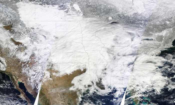
Images Modis sat - January 31 at 10:30 a.m., 12:05 p.m., and 1:45 p.m. Eastern Time

This is what climate change looks like

One of the largest winter storms since the 1950s has hit 30 U.S. states from New Mexico to Maine and now into central and eastern Canada — +100 million people affected, hundreds of thousands without power. Chicago could get buried by more than 60 centimeters (2-ft) of snow — hundreds stranded already.

Climate change is certainly playing a role in this massive storm.

1. Warmer global temps means there is now four per cent more water vapour in the atmosphere which means heavier snowfalls.

2. There is also more energy in the climate system which makes storms more powerful.

3. Finally the melting of the Arctic sea ice is changing wind patterns in the polar regions bring colder, wetter winters to the eastern US  and western Europe scientists told me several months ago. (See my previous post East Coast Blizzard and Europe’s Snowmaggddon Reveal Fingerprints of Climate Change

Climate change loads the dice in favour of extreme events.

My latest article on this The Yin and Yang of Climate Extremes We Will See More of. — Stephen

Recent related articles:

Climate Change Could Be Worsening Effects of El Niño, La Niña

Arctic Melt Down Is Bringing Harder Winters and Permanently Altering Weather Patterns

Arctic Ice in Death Spiral, Thaws Permafrost — Risks Climate Catastrophe

Will Super Cyclone Yasi be Australia’s Katrina? Landfall Wed as Cat 5 Storm

This is what climate change looks like

[Stunning satellite photo of Yasi on landfall here.]

[Update 24:00 EST Feb 2. Can it be true? No one has been killed or seriously injured? If that holds up over the next few days it will be absolutely stunning. Kudos to Australian govt and Australians.

[Update 17:30 EST Feb 2. Yasi has moved well inland leaving devastated coastal towns and landscape behind – houses flattened, 90% of trees broken, not a leaf left on bushes. Pix here

[Update 10:30 EST Feb 2 LANDFALL: South of Cairns at the beautiful town of Mission Beach as Cat 5. This is where Cyclone Larry came ashore in 2006, the worst cyclone in 100 yrs, and destroyed much of the area. The last 1500 endangered cassowaries — large flightless bird — live in the jungles there.

[Update: 18:00 EST Feb 1- Yasi landfall expected at high tide bringing storm surge of 3-4 9! metres propelled by 280-300 kph winds. City of Cairns in direct path. “Catastrophic” storm says Premier]

Following the recent record-breaking flooding, Queensland, Australia’s is facing yet another extreme weather event as super cyclone Yasi bears down on them. Yasi is expected to reach has reached dangerous Category 4 5 strength, generating winds of up to 280 300 kph when it hits the Queensland state coast early on Thursday (2pm Wednesday, GMT). Yasi is a huge storm as the satellite image above shows – it is about 600-700 km diameter making it an extremely large cyclone (cover half the USA). (Latest Met service satellite imagery)

For comparison Hurricane Katrina was also very large but only about a Cat 1 or 2 on landfall based on final data from NOAA that went largely unreported. Katrina’s storm surge caused most of the damage which could be the case with Yasi. One major difference is that Queensland does not have a major city on the coast (or even a small one protected by poorly designed levees). Shockingly even a year after Katrina more than 500,000 people remained displaced.

Large areas of Queensland are still underwater or mud-covered from flooding just 2 weeks ago that caused billions of dollars in damage. It was so bad that Australians now have to pay a temporary flood damage tax to help cover the costs… And now Yasi.

Australia may need a permanent climate change disaster tax.

This is what climate change looks like – record-breaking extreme weather events. The Queensland floods nor Yasi are the direct result of climate change. However because burning fossil fuels traps more of the sun’s heat in the atmosphere the odds and strength of extreme events increase as climate science has stated for two decades now. Here is my latest article on this The Yin and Yang of Climate Extremes We Will See More of.

Climate change loads the dice in favour of extreme events. Queensland has been very unlucky lately. Help them out if you can. — Stephen

This independent environmental journalism depends on public support. Click here learn more.

Related stories

First Ever: Two Hurricane Landfalls on Same Day – Pix

Flying Blind Into Future Hurricane Seasons

Philippines hit by 13 Major Storms 2007